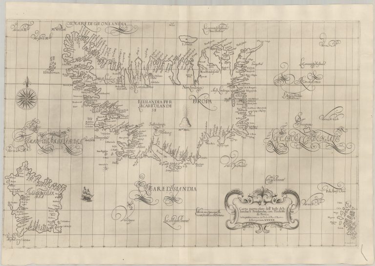
Dudley moved to Italy, in self-imposed exile, where in the years 1646–47 he created a
large atlas of sea charts, Dell’ Arcane del Mare, or the secrets of the sea. The outcome was a collection of spectacular charts, detailed and beautifully done, but not always very accurate. The map of Iceland, Carta particolare dell’ Isole di Islandia e. Frislandia, con Isolette di Fare, is quite detailed, both in how the coast is depicted, but also in the fact that there are 265 place names on Iceland. Many of the place names, however, are fabricated or repeated. As for the coast, its outline goes
back to how things were before the map of Guðbrandur. It feels a bit like an attempt to give an undeserved impression of accuracy. This is something Dudley was reputed to have done. The shape of Iceland makes me think again of some sort of creature. It seems to have had the Carolus map as its base, with the hind legs short or not fully stretched. All the maps in this atlas have this distinct style.
The only place marked on the interior of the map is the fire-spewing Hekla, there are no rivers or lakes and gone are the mountain chains that were a prominent feature on the Dutch maps. This reflects the difference between terrestrial maps and sea charts. Conversely, and oddly, there are no
rhumb lines or sounding depths. This is a bastard, beautiful in its way, but useless or worse.
Tis takes us to Frisland, also on this hybrid map/chart. It is prominently displayed Southwest of the country. It has no less than fifty place names, most of them made up by Dudley.