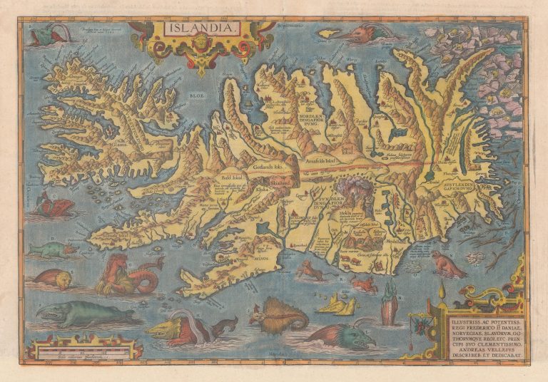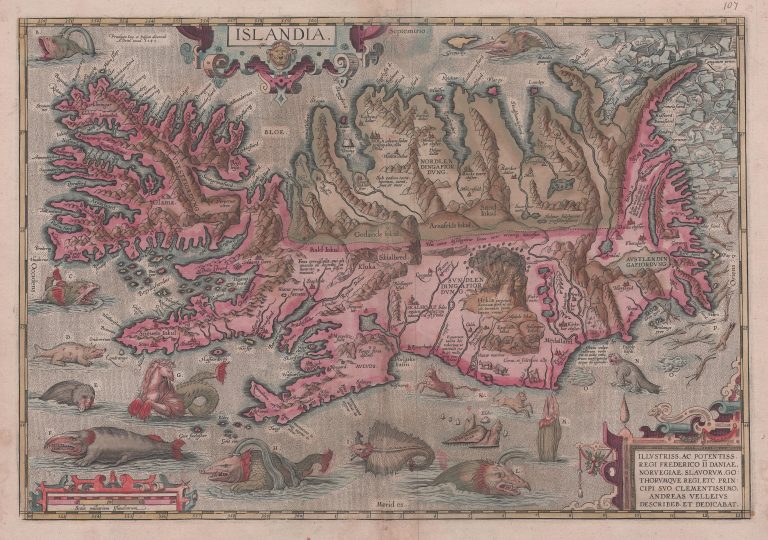
Islandia, by Abraham Ortelius, is not only the most beautiful stand-alone map of Iceland but among the most revered printed maps available. Ortelius did not create this map himself. Most of his maps were based on the work of others as must have been true of most cartographic work at this time. Ortelius was actually very open about using others’ work and frequently listed his sources. In this case, Ortelius tells us in the box in the lower right corner that the maker is Andreas Velleius (Anders Vedel (1542–1616), a famous Danish historian. But what were Vedel’s sources? It is obvious from this map that the author knew Iceland rather well. How else could he have been this accurate about the outlines and place names, roughly 250 in all? Even the beasts around the country are given Icelandic names. It is now generally accepted that the map was made by Guðbrandur Þorláksson, bishop at Hólar in Northern Iceland. This is not beyond doubt, but it is clear that someone in Iceland helped create this map, at the very least. Guðbrandur was the most learned man in the country at that time; he had even made a different map and took some measurements using the stars. Thus, it is likely he has the honor of creating this map. To put it another way, there wasn’t anyone else smart enough or learned enough in Iceland at this time to have completed such a work. Apart from being a breakthrough as a depiction of Iceland, the Ortelius map is a work of art. It is one of the most decorative maps ever made and it is full of legends and small stories. It is approximately on the scale 1:1,700,000. The position of the country N/S is between 64° and 67° ¾ N latitude. The Prime Meridian (mark 0/360°) goes through Iceland roughly a third of the way through from the West.
On the verso (reverse) of the map is a description of Iceland, which was followed closely by later writers. Ortelius says that Iceland is not Thule, for that notion was mostly relegated to the past. Some of the things in his description are actually shown on the map. As an example, there is the story of foxes so smart that they work together to get otherwise unreachable eggs on cliffs. The first fox is lowered from the top, with the second biting his tail. The third one bites the tail of the second one and he goes off the cliff as well, etc. They thus form a chain to reach the eggs. One appears to be standing guard.
The sea is swarming with creatures, and many are menacing looking. There are no less than fifteen polar bears on the drift ice East of the country. Each swimming creature has a letter attached which refers to the explanation on the verso. Most of these are from known sources, mainly Olaus Magnus and Münster, but some are Icelandic and so could have come from
Guðbrandur. On the map, there are also small stories or statements. For example, on Reykjanes there are statements about two springs, one that turns white wool into black, the other black to white. Glaciers are shown and named for the first time. And Hekla is here in its greatest majesty, described in Latin as a stone-throwing place of eternal damnation. Ortelius’s Islandia is dated 1585, but it only appeared in his atlas from the year 1590 onwards, and for the last time in 1612. It is known how many atlases were printed in each language and in each year. Therefore, we have rather a good idea about how many copies of this map were printed, just over 4,000. How many survive we do not know, but it is not a rare map. But rarity is not all, fortunately, for it would be a shame if value attached to maps (or any collectibles) did not consider beauty as well as scarcity. The map is therefore rather expensive, costing much more than any other stand-alone map of Iceland.
Explanations of the creatures on the map can be found here XXX.