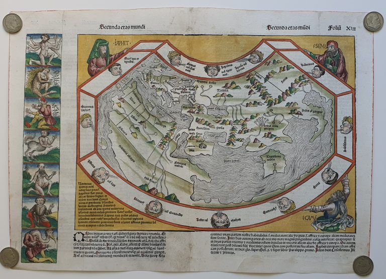
Liber Chrinicum, or The Nuremberg Chronicle, was a landmark in fifteenth century printing. It appeared in Latin and German and was a huge commercial success. It was the first book not devoted to religion to use illustrations. And this was done on no small scale, with over 1,800 woodcut illustrations. The subject of the book was world history from its creation to the End of Days. The publisher was Hartmann Schedel, a well-known physician, writer and book collector. The maps in the book are often credited to him.
This is the world map from the Nuremberg Chronicle has a world map. It is quite decorated, with heads around it, representing the twelve winds defined by Aristoteles, and other decorations. The three people around the map are Ham, Shem and Japhet, the three sons of Noah, who would repopulate the Earth after the flood. The map is based on Ptolemy and not very detailed. The coast of Africa is shown further south than on older maps, but Dias´ rounding of the Cape of Good Hope is omitted, the Indian Ocean is landlocked. There is a big island in the Indian Ocean, which is supposed to be Ceylon (Sri Lanka), way too big and wrongly placed. The mapmaker does not bother with Scandinavia, even if that region was shown on printed maps in 1482 and 1486. The Nile River is a prominent feature in Africa; here, its origins are shown in a cluster of mountains at the rim of the map. The Far East is also omitted.