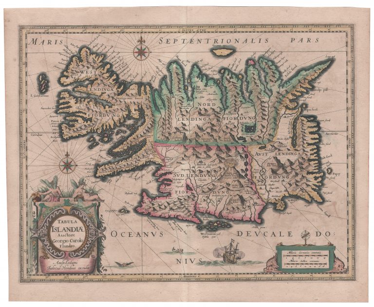
This is one of the most important maps of Iceland ever made, ranked only behind the Islandias of Ortelius and Mercator. In my book about Maps of Iceland this is the only map that actually has a whole chapter dedicated to it. This is because of how influential it was, copied and replicated, and for so long time. There is some doubt about who actually created the map. Haraldur Sigurðsson, Icelands main expert on antique maps of Iceland believed that Jodocus Hondius Jr. was mainly responsible for it. However, Joducus (Jr.) himself credited Joris Carolos for the map in its title, so Carolus must have played a significant role in creating it and called on his direct knowledge from visiting Iceland. Jodocus Jr. may have published the map in some special collections of maps (as opposed to mass-published atlases) from 1614 or 1628, (according to sources, the latter is more likely) until his death. It also seems to have been published separately, but not on a large scale; as such, the map with Jodocus‘ signiture is rare. The one copy I have is blank on the verso, making it likely it was issued separately.
The Carolus map of Iceland was among the maps that Jodocus Hondius Jr. had prepared for a new publication of the Mercator/Hondius atlas. The Mercator map of Iceland from 1595 was becoming old and one can presume that to get people to buy the new atlas, you could not sell them too much of what they already had. The new map is titled Tabula Islandiæ – Auctore Georgio Carolo Flandro. The signature under the title says: Amstelodami Jodocus Hondius excudit.
The map is quite decorative, with a large cartouche for the title and signature, topped by two angels pouring water. There is a decorative legend for scales, two compass roses and a ship South of the country. Also, there are two creatures half submerged, a faint connection to the maps of previous generations. The time of monsters was about to end. The map is on the scale of ca. 1,1600,000, or a bit bigger than the maps of Ortelius and Mercator, from 1590 and 1595. It has 270 place names. The coastline seems to borrow more from Ortelius, while places and names are almost exclusively from Mercator.
At first sight, one does not see much improvement from the shape of Iceland as it was in the hands of Mercator and Ortelius. There are even things that are markedly worse than in the older maps. As an example, the lake on the East coast, Lagarfjót, is now a long ford, with islands. Another example is I. Gouberman, the Islands of Gouberman (isl. Gunnbjarnareyjar) West of the Westfords, which actually don’t exist. The overall shape of the country is closer to reality though, regardless of the skewed shape of the western coast, particularly because the length from East to West is closer to what it actually is. Hekla is in its place, spewing fire, as ever. The interior of the country is not much improved, if at all; it is still dominated by chains of mountains and the glaciers are nowhere to be seen. Vatnajökull, the biggest glacier in Europe would actually not appear clearly on a map until 1771.
When Hondius (Jr.) died in 1629, his widow sold the plates to Willem Blaeu. It appeared the next year in Blaeu’s new atlas, titled as an appendix to the Mercator atlases.