The initial publications of Ptolemy’s Geography did not have any maps of the Nordic lands and the region was hardly ever depicted on contemporary regional maps either. The reason for this is that earlier publications had only classical maps, i.e. maps that reflected the knowledge of the world around the time of Ptolemy. Thus, the northernmost limit was roughly 63° North.
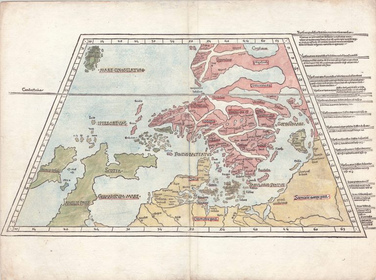
The first publication of Ptolemy’s Geography produced North of the Alps was in Ulm, Germany, in 1482. The publisher was Lienhart Holle. This edition is where Iceland first appears on a printed map. In fact, it is on two separate maps. First, on a map titled Tabula Moderna Prussie Livonie Norbegie et Gottie, the first map dedicated to Northern Europe, thus the word Moderna in the title. Second, Iceland also features on a world map.
The map Northern Europe was based on a model by the Dane Claudius Clavus. Maps made by Clavus only exist in a limited number of copies; there are no originals extant. The copies differ particularly when it comes to Greenland; it appears either as part of Scandinavia or as a country West of Iceland not dissimilar to what it is. Unfortunately, it would be the Greenland as part of Scandinavia, which would be the role-model for the first printed maps showing the Nordics. It was Donis Nicolaus Germanus who created the map, based on Clavus, which would appear in the Ulm edition of Ptolemy’s Geography, Tabula Moderna Prussie Livonie Norbegie et Gottie. The Ulm Scandinavia, as the map is often called, became the foundation for cartography of the Nordics for the next half a century or so. It was republished in 1486, using the same plates.
Unsurprisingly, Iceland was not very accurately depicted the first time it appeared in print. It has an oval shape (my mother says it looks like a turtle), with nine islands surrounding it, and owes its appearance to the earlier works of Clavus. The word Islanda is clearly written (Iceland in Latin), but most of the other place names don’t make much sense. The Bishoprics seem, however, to be labeled and there are six rivers. There are ten dots around the coast, presumably depicting towns. Next to Iceland is “Mare Congelatum” or the frozen sea. The map is much wider at the bottom than it is at the top. This was traditional on maps in the Ptolemaic tradition, the reason being that the distance between lines of longitude as they approached the pole decreased. The other option would be to keep the lines parallel and stretch the area being shown, a method later incorporated.
The same map appeared in the 1486 edition published by Johan Reger.