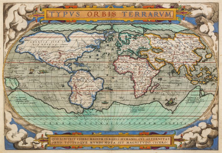
“Who can consider human affairs to be great, when he comprehends the eternity and vastness of the entire world?”, this is the quote from Cicero which appears at the banner below the map.
This world map appeared in the first standardized atlas and as such is of great importance in the history of cartography. It is on an oval projection, as the earlier maps of Appian and Bordone. Ortelius was always very willing to name his sources and in this case, they are Gerard Mercator (1569), Gastaldi (1561), and Gutierrez. by Peter ab Aggere of Mechelen, Sebastian Cabot of Venice, Laurent Fries of Antwerp, Jacob Gastaldi, Gemma Frisius of Antwerp, Guicciardi of Antwerp, Doco ab Hemminga Frisius, and Oronce Fine of Paris.
There are many areas on the map which are highly speculative. This is particularly true of America, which had only been discovered less than a century before. There is a big bulge on the west coast of South-America, which would be amended on later editions of the map. Australia has not been discovered, the big landmass around the South Pole is the mythical TerraAustralis or South Lands, believed by the ancient Greeks, including Aristoteles, to exist as some sort of counterbalance to the lands in the northern hemisphere.
Among other things of interest, as an example, see the shape of the Caspian sea and the fact that there is no Korea.
Along the bottom of the map there is an apt quote by Cicero, in translation,
This map was engraved by Franz Hogenberg, whose imprint appears on the map, low margin and center.
See Rodney Shirley, Mapping of the World, nr. 122.