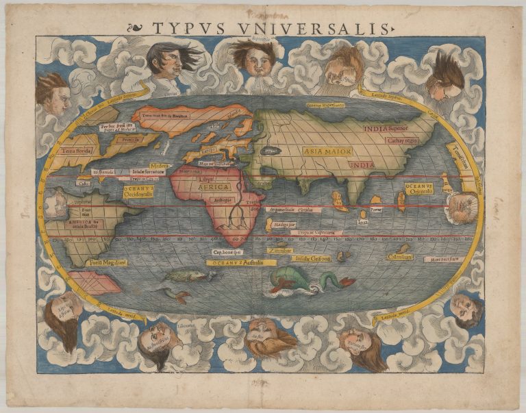
Münster’s ‘modern’ map of the world presented on an oval projection surrounded by clouds and wind heads.
There are many interesting things to see on this map. This is less than 50 years after Columbus first sailed to America and the knowledge of that continent is still fragmented. See the cleft in the northern continent and what appears to be a passage between the Atlantic and Pacific Oceans, the latter being named for the first time on a map.
In Africa, the most noteworthy thing is the river Nile, originating in mountains in the southern part of the continent. These are the Mountains of the Moon, the legendary source of the Nile. Keep in mind that it is also less than 50 years after Africa is rounded and the progress from earlier maps is evident.
Greenland and Canada joined together in the land of Terra Nova sive Bacalhos. Terra Florida and Francisca are the only place names on the eastern portion of North America, while the western coast has the name of Temistitian, presumably derived from the ancient capital of the Aztecs. The Strait of Magellan is shown at the bottom of South America and a good chunk of land south of that. noted below. In Africa, the Nile is prominently shown with its twin sources beginning in a range of southern mountains. There are two mythical island is the proximity of Australia, Grisonum and Calensuan.
South-East of India is the island Porne.
Münster put the name Islandia on Greenland, with Tule resembling the shape Ziegler had given Iceland in 1532. Note that country names are very few on the map, for example the only label on continental Europe is the name of the continent. However, there is both Tyle and Islandia so this issue must have concerned Münster.
This map appeared in Münster’s publication of the Geographia in 1541, 1542 and 1545 as well as in the Cosmographia in 1544, 1545, 1546 and 1548. Munster then remade this map, published in 1550, with one of the most noticeable differences Island is remade and rightly labeled.
Shirley #77.